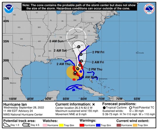
At 1100 AM EDT (1500 UTC), the eye of Hurricane Ian was located about 45 miles west-northwest of Naples, Florida. Ian is moving toward the north-northeast near 9 mph (15 km/h). This general motion with a reduction in forward speed is forecast today, followed by a turn toward the northeast on Thursday. On the forecast track, the center of Ian is expected to move onshore within the hurricane warning area in a few hours, move over central Florida tonight and Thursday morning and emerge over the western Atlantic by late Thursday. Ian is forecast to turn northward on Friday and approach the northeastern Florida, Georgia and South Carolina coasts late Friday.
Maximum sustained winds remain near 155 mph (250 km/h) with higher gusts. Ian is a category 4 hurricane on the Saffir-Simpson Hurricane Wind Scale. Ian is forecast to make landfall on the west coast of Florida as a catastrophic hurricane. Weakening is expected after landfall, but Ian could be near hurricane strength when it moves over the Florida East coast tomorrow, and when it approaches the northeastern Florida, Georgia and South Carolina coasts late Friday.
Hurricane-force winds extend outward up to 45 miles (75 km) from the center and tropical-storm-force winds extend outward up to 175 miles (280 km). The estimated minimum central pressure is 937 mb (27.67 inches).
Visit the National Hurricane Center website at hurricanes.gov for additional forecast information on Ian.
On the road? Why not take us with you. All our websites are mobile-friendly. Visit our growing family of exit guides: I-4 Exit Guide, I-5 Exit Guide, I-10 Exit Guide, I-75 Exit Guide, and I-95 Exit Guide. Detailed exit service listings… discount lodging, camping, food, gas and more for every exit along the way!


